Preserving the Archipelago
FALL 2024
CORNELL UNIVERSITY ARCH 5101 DESIGN IX
PROFESSOR(S): DAVID MOON
This project reimagines Floyd Bennett Field in Brooklyn, NY, by restoring its landscape to its original 1890s form while addressing historical significance and the challenges of rising sea levels. Once an archipelago, the island was infilled in the 20th century with dredged soil from Jamaica Bay. The design reintroduces this archipelago layout, using dredged soil to create berms around historical structures, elevating the site to protect them from flooding and preserve its integrity.
The approach includes excavating the historic runway, honoring its aviation legacy, creating a boat transportation route, and removing toxic soil. The project also enhances the ferry route and introduces 10 architectural interventions—some based on preexisting programs and others, like a site museum, focused on the site’s history and ecology. These interventions serve to connect different parts of the islands, promoting unique foot travel and improving site-wide connectivity.
An elevated light rail running along the berms will improve access from Brooklyn, with a walking path alongside it for additional pedestrian routes. Together, these interventions create a dynamic, water-responsive space that enhances connectivity while preserving the site’s history.
In its entirety, the project explores infrastructural, ecological, and architectural concepts across multiple scales and timeframes, offering a comprehensive vision for the site’s future.
SITE FLOODING ANALYSIS
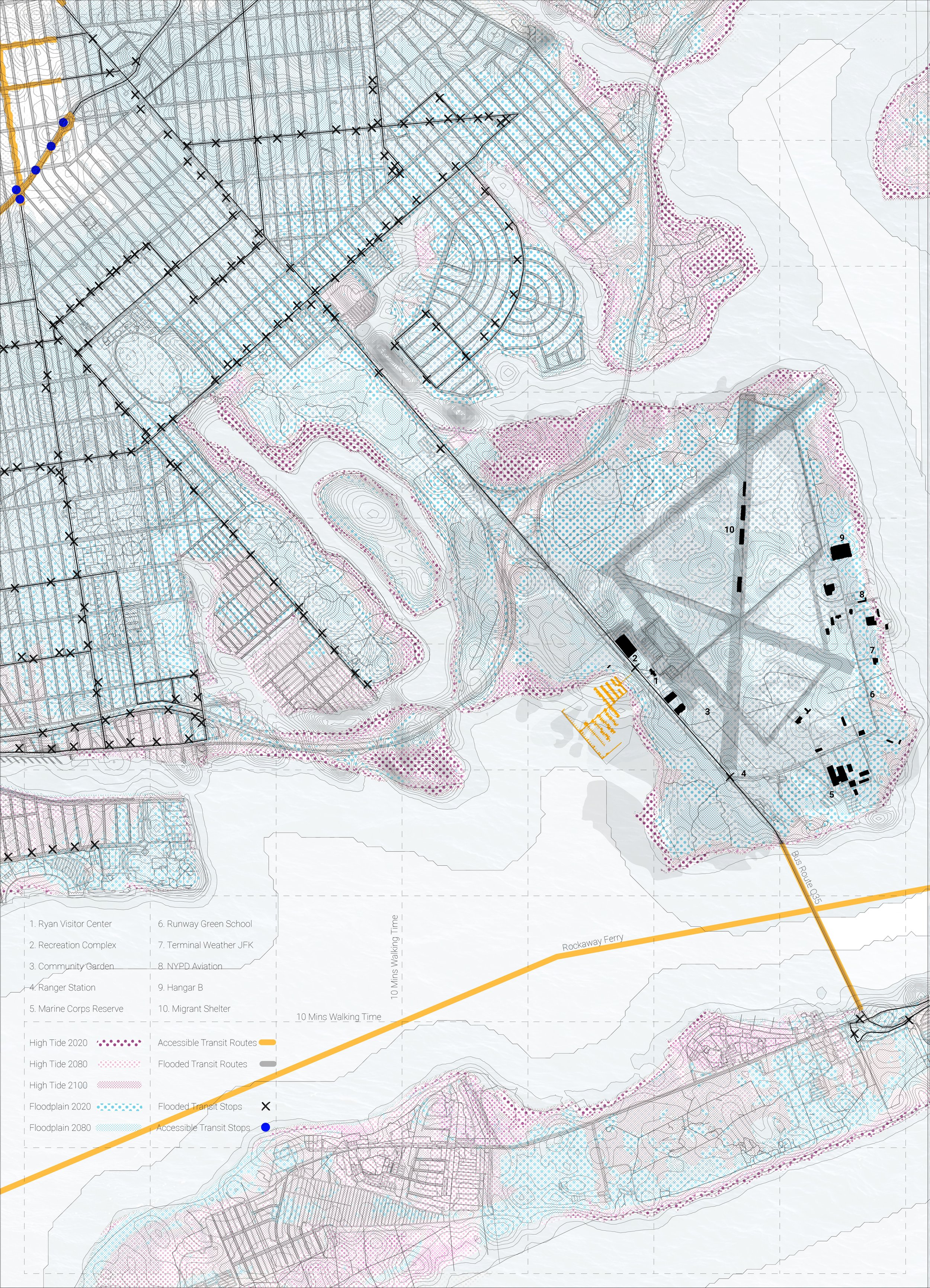
This site flooding analysis drawing depicts Floyd Bennett Field, located on Barren Island in Brooklyn, while forecasting the potential impacts of rising water levels in the future. The drawing highlights the increased flooding risks, showing the site’s vulnerability to high tide events and the potential destruction caused by these elevated water levels. As the waters rise, the surrounding local infrastructure, including vital bus routes connecting Brooklyn and the Rockaways, is likely to sustain significant damage, making it unusable. The drawing emphasizes the urgent need for adaptive strategies to safeguard the site from these environmental changes, ensuring it remains protected against future flooding threats.
SOIL COMPOSITION ANALYSIS
This site soil composition analysis drawing illustrates the complex layers of soil that make up Floyd Bennett Field, a site with a rich and evolving history. Originally an archipelago in 1890, the land was gradually infilled throughout the 20th century with 6 million cubic yards of soil dredged from the surrounding areas of Jamaica Bay. This effort raised the land by 14 feet to create New York City’s first commercial airport, which ultimately failed due to its isolation from Manhattan. The drawing categorizes the various soil types found across the site, including Bigapple, Hooksan, Wethersfield, Greenbelt, Breeze, and Canarsie, which together form the majority of the island’s composition. Additionally, the analysis highlights sections of the island where 20 feet of industrial pollution and household garbage were used as fill material, a consequence of the site’s former use as an additional landfill for New York City. This detailed drawing underscores the unique and layered soil history that defines the site’s current condition, and shows how the island has adapted its form to fulfill the needs of the program that occupies its land.
SITE PROGRAM ANALYSIS
In addition to the historic buildings that define Floyd Bennett Field, the site is home to a variety of secondary programs that are an integral part of its daily use and vibrant community. These programs, such as the community garden, RC plane club, kayak launch, emergency housing, and archery range, attract locals who have developed strong connections to these spaces, often visiting them regularly. During our visit, for instance, we parked near the archery range, where we were informed that members needed the parking space for their activities, highlighting the active nature of these programs. Furthermore, the ongoing development of the site is evident with the construction of the new Launch School, signaling that the site is continuously evolving with new programs. When we spoke to a representative from the school about flood preparedness, they mentioned that they are adhering to the required codes, yet they did not appear to have comprehensive plans for dealing with the imminent flooding risks. This response suggests that, while the site remains a dynamic and growing community hub, the future challenges posed by rising waters are not being fully addressed in current plans.
Phasing gif showing the evolution of the original archipelago of Barren Island to Floyd Bennet Field through heavy land infill, followed by our restoration of the former archipelago form
Overall site isometric drawing showcases the return of Barren Island to its original archipelago form, the use of the newly dredged soil to create berms around the preexisting structures on the site , and the introduction of the proposed architectural interventions that provide a home to the secondary programs on the site.
Airplane Museum Extension
Archery
Ferry Stop
Cafe + Commercial Spaces
Kayak Launch
Emergency Housing
RC Plane + Car club
Marina
Site History Museum
Aquatic Research Center
AIRPLANE MUSEUM EXTENSION
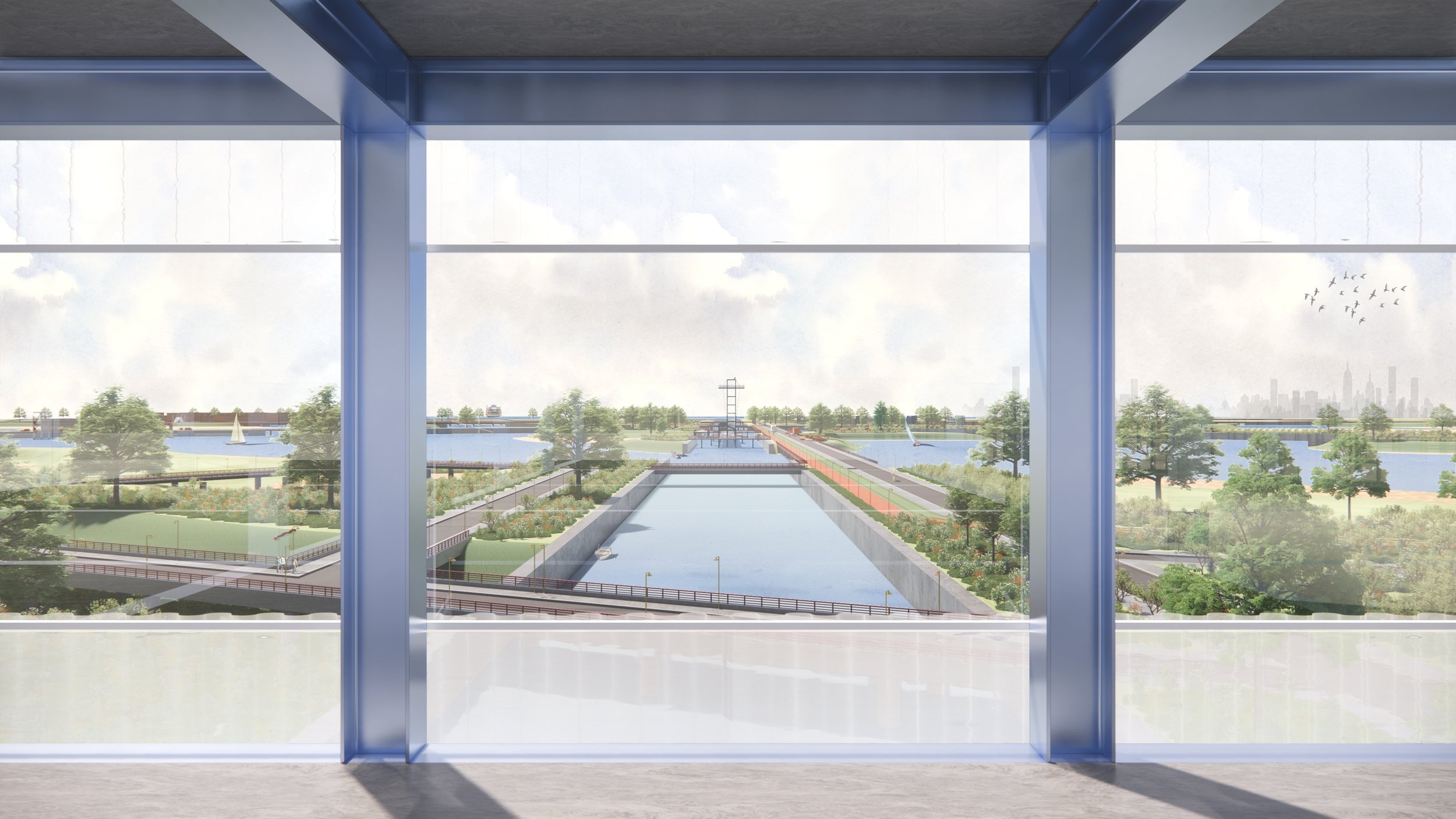
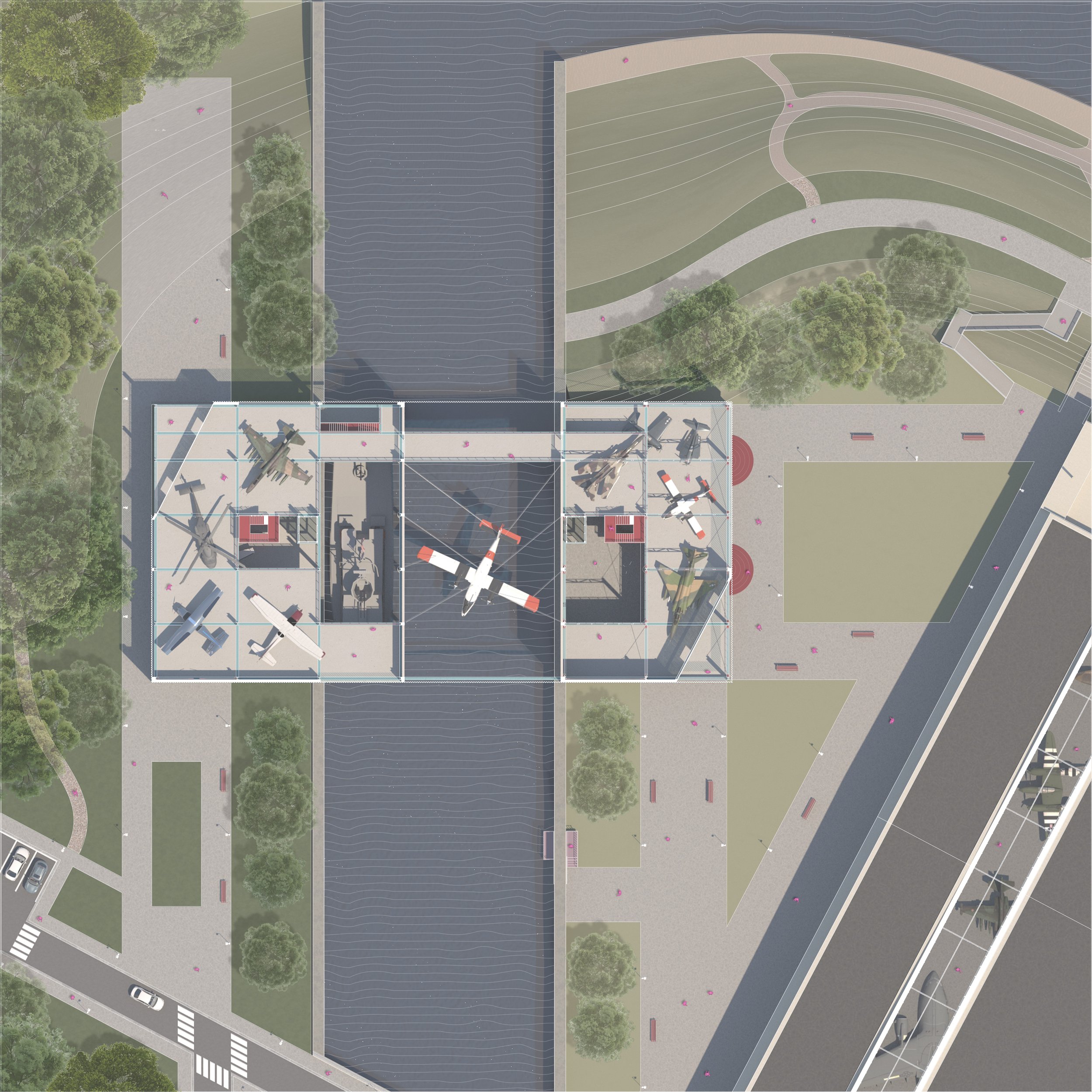
One of the most significant architectural interventions in our proposal is the extension of the airplane museum, designed to expand the museum’s capacity while preserving its integral role in showcasing the rich aviation history of Floyd Bennett Field. The museum houses and displays planes that were flown at the field or used during its time as a military base in World War II, making it a key historical landmark. We focused on the airplane museum extension for our main plan and sections because it embodies several of the core design strategies proposed for the site, including connectivity, flood resilience, and historical preservation. The new structure will bridge a gap created by one of the proposed waterways, seamlessly integrating the museum extension with the surrounding landscape and further enhancing the site’s connection to its natural environment. At the same time, the extension will preserve the original museum’s visibility, with its sunken structure remaining at its original elevation, while protective berms—formed from the dredged soil—will safeguard the building from future flood risks. The existing museum is a vital part of the local community, attracting visitors of all ages, including school groups, and reinforcing its significance as both a cultural and educational hub. Expanding the museum’s space will allow for a broader display of exhibits and ensure that the site’s aviation history is better preserved and accessible to a wider audience. This intervention not only honors the site’s legacy but also future-proofs it by making it more resilient to rising waters, securing its place as a lasting resource for both locals and visitors.
AIRPLANE MUSEUM EXTENSION SECTIONS
The section drawings of the airplane museum extension shows how the new structure enhances connectivity, flood resilience, and historical preservation. It bridges a gap created by a proposed waterway, integrating with the landscape and preserving the original museum’s elevation. Protective berms made from dredged soil surround the building, safeguarding it from future flood risks while maintaining its historical integrity.


